|
|
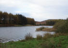 A delightful
lake in a delightful setting. A walk around Cod Beck Reservoir includes just about every type of scenary you will find in the moors. The car parks at the top of the lake are in a valley between Scarth Wood
A delightful
lake in a delightful setting. A walk around Cod Beck Reservoir includes just about every type of scenary you will find in the moors. The car parks at the top of the lake are in a valley between Scarth Wood 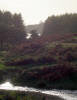 and Pamperdale Moors, with paths leading up onto the high moors. As you walk down the western side of the lake, you enter farming country, with small fields running up to the nearby ridge.
At the southern end of the lake you get a view down the valley towards Osmotherley. Finally, on the eastern side of the lake you walk through a conifer forest. Even the Cleveland Way passes within half a mile of the lake!
Follow the only road north out of Osmotherley
Several car parks can be found at the head of the lake.
The pleasant walk around the lake is just under two miles long.
 Cod Beck Reservoir is on Ordnance Survey Explorer Map OL26 (North Yorks Moors Western Area)
Get it from ![]()