NZ 6507/01 Baysdale
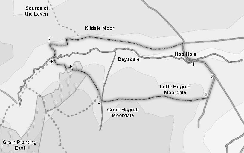
This walk takes us into Baysdale, a most unusual valley with wild heather at its base and a pocket of pastoral land at its head, the reverse of the normal pattern. Our walk starts at Hob Hole, surrounded by heather, and takes us up to the top of the valley, crossing Little and Great Hograh Moor on the way. We also get great views into Westerdale and the upper reaches of Esk Dale.
Ascent: 700ft/ 210m
Length: 4.5 miles/ 7.3km
Map: Ordnance Survey Explorer Map OL26
Last Walked: 1 May 2008
We start this walk from the car park at Hob Hole, just over two miles west of Castleton, on the minor road that runs north from the village of Westerdale.
1 (NZ 652 074)
Starting from the Hob Hole car park, turn right onto the road, cross the footbridge across Baysdale Beck and follow the road as it climbs steeply out of Baysdale.
2 (NZ 656 071)
Towards the top of this slope, a side road branches off to the right (John Breckon Road according to the OS maps). Turn right and follow this road as it runs across Little Hograh Moor, heading towards Westerdale.
3 (NZ 654 067)
We stay on this road for the next quarter of a mile, until we reach the first signposted footpath, leaving to the right, just at the point when the road is starting to loose height. Turn right and follow this footpath (Skinner Howe Cross Road) as it runs across Little Hograh Moor and Great Hograh Moor.
4 (NZ 635 067)
We stay on this path for just over a mile as it runs west across the open moor, dipping down slightly to cross Little Hograh Beck about half way along. After about a mile the path passes through an area of exposed rocks, before dropping down into the larger valley of Great Hograh Beck. Our path crosses this beck on an impressive little stone bridge, built in 1938. Just across the stream the path splits, with one branch climbing steeply up the hill while the second branch turns off to the right, and climbs rather more gently up out of the valley. Turn right and follow this path. After a short distance the path merges with a moorland track - continue on in the same direction, heading north west around Holiday Hill towards the upper reaches of Baysdale.
5 (NZ 630 072)
We follow this path across the moor and into a small patch of woodland. At the opposite side of the trees we approach the Low House Farm. Our path passes around this house to the right, crossing into the field to the right of our track. We then curve around the right hand side of the house and join a farm track that curves across the fields heading towards a barn close to Baysdale Beck.
6 (NZ 627 074)
This track passes to the left of this barn, and then curves away to the left and heads away up the valley. Just past the barn a footpath leaves to the right, heading towards a bridge over Baysdale Beck. Turn right and follow this path down to the beck. On the far side of the beck we enter a steeply sloping field. Our path zig-zags across this field, first heading right towards a ruined building, and then left towards a gap in the line of gorse bushes at the top of the field.
7 (NZ 627 077)
Leave this field through a gate in the northern wall, directly ahead of the gap in the gorse bushes. On the far side of the gate turn right and follow a path that runs along the northern side of the dale, eventually running all the way back to the road above Hob Hole. For just over half a mile this path runs to the left of a stone wall. On a couple of occasions shortcuts appear to cut off corners, but in each case the shortcut is much wetter under foot than the wall-side path, so stick close to the wall.
After half a mile the wall ends, and the path continues east across the side of the moor, heading back towards Hob Hole. If you are willing to go cross-country, then once Hob Hole is in site it is possible to cut across the heather and return to the car park by the side of the beck, but otherwise follow this path until it reaches the road that leads into Hob Hole, turn right and follow this road back to the car park.