SE9887/02 Derwent Sea Cut
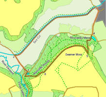 This walk takes us along the Derwent Sea Cut, a remarkable piece of engineering built to control the devastating floods that once plagued Forge Valley. We then return along the top of Raincliffe Woods, with glimpses across the valley towards the Derwent.
Ascent: 550ft
Length: 6 miles
Map:
Ordnance Survey Explorer Map OL27
Go to printable version
We start from the car park in Raincliffe Woods - if approaching from the south take the right turn at the northern end of Forge Valley.
1 (SE 984 875)
Cross the road outside the car park and look for a path that runs through the woods, cutting a corner to the road north. Take this path, then turn right onto the road and head north, away from Forge Valley and towards the Sea Cut.
2 (SE 980 882)
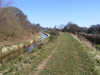
This road runs straight across the flat ground until it approaches the bridge over the Sea Cut at Mowthorpe Farm. Just before the bridge turn right onto the southern towpath of the Sea Cut, and follow it as it runs east, with the canal to the left.
3 (TA 010 899)
Follow this path along the Sea Cut all the way to the western edge of Scarborough, where the path runs up onto a road crossing the canal. Turn right onto this road, and then take the first right, onto a side road that runs south, climbing up past Throxenby Hill, with houses on the left and a clear view towards the moors on the right.
4 (TA 008 889)
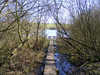
This road eventually brings us to a T-junction overlooking Throxenby Mere. Cross the road and then follow a footpath that passes to the right of the mere and then climbs up into the woods behind. At first this path climbs up around Cock Hollow, curving around to the right. It then turns sharply to the left and climbs up to join another path, climbing up from right to left. Turn left onto this path, which almost immediately branches - take the right-hand branch which continues to climb up the bank. Follow this path all the way to the top of the slope.
5 (TA 007 883)
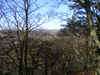
At the top of the bank turn left and follow the track that runs around the top of Seamer Moor, with open fields to the left and the trees to the right.
6 (SE 990 875)
Follow this path for about a mile and a third. At this point the path splits - the main track continues on in a straight line into the open fields, while a smaller path branches off to the right to follow the edge of the trees. Take this right hand branch and follow it along the edge of the woods for about a fifth of a mile, until it reaches a junction with another path that rises up through the trees from the right before dropping down again, heading west. Follow this branch (forward right) as it drops down through the trees. Continue on in the same direction when it joins another track, before turning right at the next T-junction onto a track that returns to the car park.