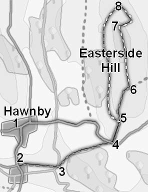
Easterside Hill dominated the entrance to Bilsdale, standing between the River Seph and the River Rye, and is a familiar landmark to anybody driving up the B 1257 between Helmsley and Stokesley
The top of Easterside Hill is now access land, but there is no footpath that reaches the summit and no real paths that lead off the northern edge of the hill, so this walk does involve walking across the heather, and a minor scramble as we climb 150 feet down the side of the hill.
The first part of this walk, alongside the River Rye, can be very very wet. If in doubt use the road route to reach point 4, but the ascent from river level gives a much better feel for the scale of the hill.
Ascent: 900ft/ 280m
Length: 4 miles/ 6km
Map: Explorer 026 North York Moors West
There is a limited amount of roadside parking in Hawnby. Take care not to block any gates or impede access.
Somewhat to my surprise Easterside Hill has a summit cairn, even though no paths actually reach it! Our problem now is how to get off the summit. My preferred route involves a scramble down the eastern flank of the hill. Start by heading north from the cairn towards the northern edge of the summit cairn. Once there turn round and look back to the south. From here a small groove (probably an old quarry) is visible on the eastern (left) slope of the hill. Head back into this groove and then follow the maze of sheep tracks that will eventually lead you down to the base of the hill.
The OS map shows a footpath that curves around the northern edge of Pepper Hill, through High Banniscue and back to the road. We are not going to take this route. Instead, there is a path that stays high on the western slope of Easterside Hill, running just inside the area of open moorland that surrounds the hill.
At the base of the slope turn left and head towards the wall at the southern edge of the field that lies below the northern edge of the hill.
A very clear path follows this wall, curving all the way around the western slopes of Easterside Hill. Turn left and follow this path all the way around the hill, with the open moor to the left and fields to the right. This path then runs past the eastern flank of Banniscue Wood. before curving around to the left to rejoin our original path at step 5. This time turn right onto the path and re-cross the field back to the small lane.
Turn right onto this lane, and follow it as it winds its way down into the valley between Hawnby Hill and Easterside Hill and then climbs back up into Hawnby. Just at the edge of the village we reach a t-junction. Turn left and follow this road as it curves around the right and back to our starting point.