NZ5911/01 Roseberry Topping and the Cook Monument
This walk visits two of the best known viewpoints on the northern Moors (Roseberry Topping and the Captain Cook Monument) and one less well known one (The Hanging Stone overlooking Guisborough).
I last walked this route on the day of the England-Portugal match in the 2006 World Cup. Even though the match was not due to start until an hour after I finished the walk, I was actually alone on top of Roseberry Topping, something I have never achieved before or since! From the Captain Cook's Monument not another walker was visible.
This walk starts from the car park at the top of Lonsdale.
Ascent: 1500 feet/ 460 meters
Length: 7 miles/ 11 km
Map: OS Explorer Map OL 26
Last Walked: 1 July 2006
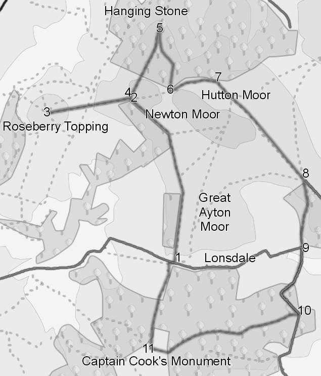
1 (NZ 591 110)
The first part of this walk follows the Cleveland Way, which climbs up the hill to the north of the car park. Follow the path as it climbs straight up the slope. At the top of the hill, the path runs north along the western edge of Great Ayton Moor, with a steep slope to the left. Follow this path as it gently curves around to the left. At the beginning and end of this section the view to the left is blocked by trees, but the central section is clear and offers views west towards Great Ayton, and Roseberry Topping.
2 (NZ 587 127)
Our path, and the Cleveland Way, now takes a diversion to the summit of Roseberry Topping. At the end of the second set of trees, the path turns left through a gate, and heads down the slope directly towards Roseberry Topping. Follow the path down into the dip, and then back up the eastern slope of the Topping, using the well built paved path up the hill.
3 (NZ 579 126)
You are now at the top of Roseberry Topping, one of the best viewpoints on the moors, so take a break to enjoy the views. Once you are ready to continue, retrace your steps down the eastern slope of the Topping, and back up onto the main body of the Moors.
4 (NZ 587 127)
At the top of the climb back from Roseberry Topping, turn left along the path that runs along the edge of the moor. After 250 meters, the path enters Hanging Rock Wood and becomes a forest track.
5 (NZ591 134)
Four hundred meters into the woods, the forest track makes a u-turn and heads back south. The OS map shows a path to the Hanging Stone leaving the forest track at the beginning of the u-bend, but the current path will be found ninety degrees around the bend. This path leads north through the trees, until emerging at the Hanging Stone. The trees below the stone have been cleared, giving us impressive views towards Guisborough, After you have enjoyed the view, retrace your steps to the forest path and continue along it. .
6 (NZ 592 128)
At the edge of the trees the forest track rejoins the Cleveland Way. Turn left onto the path and follow it east around the edge of the woods.
7 (NZ 597 129)
After around 500 meters running alongside the woods, the Cleveland Way turns south east and climbs up onto the moors on a very well defined path. Follow this path, but when the Cleveland way leaves it to the left, keep on the main path as it climbs up the side of Hutton Moor.
8 (NZ 606 118)
Follow the path across the open moors until it joins a paved road. Go through the gate from the moors onto the road, and then turn right onto a track that leads down the slope into Lonsdale. This area is shown as wooded on OS maps, although the first section had been cleared in 2006.
9 (NZ 606 111)
When the track joins the road, continue straight ahead along the road. This crosses Lonsdale, and then climbs up into the trees. behind Lonsdale Farm.
10 (NZ 605 104)
At the top of the hill, we rejoin the Cleveland Way. Turn right into the woods and follow the way marked route along a forest track that runs along the top of the wooded ridge. Just over 300 meters into the woods, our path leaves the forest track on a path to the left and continues to run along the ridge. This is a very pleasant walk through the woods, with a short steep climb towards the end.
11 (NZ 589 101)
The Cleveland Way emerges from the woods onto an patch of open moorland around the Captain Cook Monument. At the monument, turn right and follow the Cleveland Way as it descends back down to the car park.
Suggested Variants
The first part of this walk is a good route for the ascent of Roseberry Topping, with great views across the open moors on the way to the Topping.