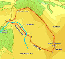
 This walk heads up onto the ridge of high ground that guards the entrance to isolated Scugdale, before heading into the heart of the moors above the sources of the River Rye, visiting the equally isolated Swainby Shooting House.
I completed this as a circular wark, contining on from Swainby Shooting House to follow a track marked as running down Ingdale Ridge, but I wouldn't recommand that option for everybody - the track exists, but is very wet (somewhere between a stream and a swamp in places), and there is no path from the end of the track back to the car park. If you enjoy walking across untracked heather (I do!) then I include this route as an option. If you don't then follow the route up to Swainby Shooting House (step 5) and then retrace your steps back along the good tracks back to the car park.
Ascent: 475ft
Length: 5 miles
Map: Ordnance Survey Explorer Map OL26
Last Walked: October 2010
Printable Version
We start from either of the two car parks by the side of the road just to the north of Cod Beck Reservoir (there were three on my previous visit but the northern one has now been removed and grassed over).
 The road runs north-east for a short distance, before swinging away sharply to the left. At this point two clear footpaths leave the road - one turns right and crosses a footbridge while
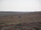
 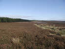 the other continues straight on ahead, climbing up to a route marks as the Red Way. Take this second path, and follow it as it climbs rather steeply up onto the flanks of Whorlton Moor. After this initial sharp climb the track swings a little to the left, levels out and heads across the moors towards a distance line of trees.
 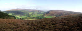 As the track approaches the trees it curves to the right, and runs alongside them, with trees to the left and the open moors to the right. Before following the track around this corner head left along a minor footpath that leads to a
 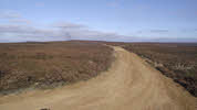 fantastic viewpoint looking north-west across the flat lands away from the moors. After this head along the track(passing a bench dedicated to the Pilgrimage of Grace!). This track runs alongside the trees for some time, before reaching an excellent viewpoint looking out across Scugdale. After this continue on along this track as it undulates across the moors, ignoring a track that branches off to the right.
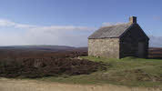 Just before we reach the building we reach another T-Junction. Once again turn right to reach the isolated shooting house.
At this point we have a decision to make - if you want to continue on with the circular route then continue on along this track - if not then turn back and retrace your steps back to the start.
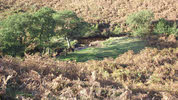 The only remaining obsticle in our way is the side valley of Ingdale Beck. Once again avoid getting too close to the point where the two streams merge, as this area is very swampy. Once across Ingdale Beck continue to follow the line of the merged beck at a reasonable distance. Eventually a path appears down by the beck (complete with short grass and signs of camp fires). Follow this path as it runs along the beck down to the footbridge we saw back at step 2. This time cross the bridge, then turn left and head back down the road to our starting point.