SE 8382/01 Thornton-le-Dale and Dalby Forest
This walk starts in Thornton-le-Dale, a village often said to be one of the most attractive in Yorkshire, before heading into Dalby Forest, the southern tip of the vast forests that blanket the eastern moors. We also visit the new visitor's centre in Dalby Forest, complete with restaurant, shop and barbeque pits.
Ascent: 1,100ft
Length: 12 miles
Map:
Last Walked: 1 June 2008
We start from the car park built into a walled garden on the road that runs south from the centre of the village.
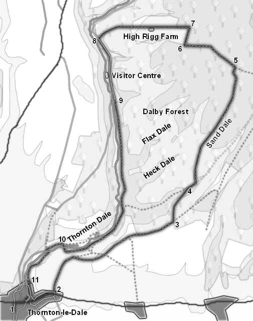
1 (SE 835 829)
Leave the car park through the gap in the western wall. This brings us onto a path that runs around the edge of a duck pond before emerging at the edge of the village green. Turn right to reach the main road, then turn right onto the path that runs alongside the main road, and head east through the village.
2 (SE 842 832)
We follow the main road almost to the eastern end of the village. As we head east the road begins to climb gently, and curve to the right, eventually hiding the village centre from view. We leave the road just inside the village, at a point where the main road makes a turn to the right, and a side road joins from the right-rear. A second lane leaves the main road at ninety degrees, heading uphill straight out of the village. Turn left onto this lane.
We follow this track all the way to the edge of Dalby Forest. For most of this distance the track runs along the southern edge of Thornton Dale, with very few side junctions. Soon after we join it a road branches off to the left to reach an old quarry - here we take the right hand branch. Ignore any branches that lead down into the valley, or that head away to the right.
3 (SE 868 848)
After about a mile and a half we reach the first part of Dalby Forest - here the trees are to the left of the track with open fields to the right. Continue along our track for another half a mile, heading for a line of trees. Just inside the trees turn left onto a track that runs downhill into Sand Dale.
4 (SE 871 853)
This track soon joins a track that runs along the bottom of the dale. Turn right onto this path, and follow it up the valley. After a short distance we reach a junction, with valleys to the left and right - take the left hand valley, and follow the track as it climbs up the valley for the next mile and a half.
5 (SE 882 878)
We follow this track until it reaches the top of the valley. During this climb we don't pass any other tracks, but just before the end a track joins from the left-rear. Just after this we reach a second junction - turn left here and follow this new track until it reaches a T-junction. Turn right here.
After a short distance this track reaches another T-junction, this time with a track that runs from east to west through the forest. Turn left onto this track. This track soon reaches a forest road, which joins from the right. Continue on in the same direction along this road for just under a fifth of a mile. At this point the road turns sharply to the left, while a forest track continues on to the west. Leave the the road and take this track.
6 (SE 871 884)
This track brings us to the edge of the open space around High Rigg Farm. Turn right and head north along the eastern edge of this open ground.
7 (SE 872 888)
After about a quarter of a mile turn right onto a track that heads out into this open ground, heading directly for the farm. Follow this track past the farm, across the western half of the open ground, and then continue on as it runs down Little Dale.
8 (SE 853 886)
This track brings us down the toll road that runs up Thornton Dale. Turn left and follow this road south for three quarters of a mile. This brings us past the new Visitor's Centre, with its shop and restaurant, and then down to the old Visitor's Centre, now a centre for bike hire.
9 (SE 856 874)
At the old Visitor's Centre at Low Dalby the road turns sharply to the right, while a path continues due south, passing to the left of the bike hire. Follow this path as it runs past the buildings of Low Dalby, and then enters the woods that line the eastern bank of Dalby Beck. Follow this track all the way to the southern edge of the trees, and then as it curves around the the right. Eventually the track passes to the left of a fish hatchery, then swings to the right to cross the beck.
10 (SE 844 842)
After crossing the beck the track curves to the left, and continues to run down the valley towards Ellerburn, and its isolated church. Ignore the road that runs down the valley from here, and turn left to cross back over the beck, heading towards Low Farm. Before reaching the main farm buildings, turn right and follow a footpath that runs alongside Thornton Beck. Follow this path as it runs alongside the back, and then along a minor diversion that brings us back into Thornton-le-Dale.
11 (SE 836 834)
Turn left onto the village street, and follow it as it runs south, with the beck to the right. After just over 700 feet the beck swings to the right, and the road to the left. Just before this cross a footbridge over the beck, and follow a path that runs alongside the back, passing a beautiful thatched cottage, and then returns to the main road in Thornton-le-Dale. Turn right and follow the road back into the centre of the village. At the village green take the footbridge that re-crosses the back and return to the car park.