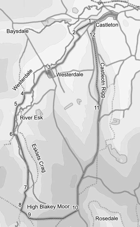
This walk takes us along the full length of Westerdale, from its start close to Castleton to the source of the Esk in the streams that run out of Esklets Crag at the upper end of the valley. We then cut across the top of the moors and return along Castleton Rigg, a good high-level route with extensive views.
Ascent: 1,400ft
Length: 12 miles
Map: Explorer 026 North York Moors west
Last Walked: 26 July 2008
We start from a roadside car park just to the west of Castleton, on the side road that branches off from the main road down Castleton Rigg just as that road turns sharply to the right to enter the village.
Our path runs to the right of the stone buildings at Wood End, then passes through a line of trees in the next field. Ignore the track that runs across this field and continue along the path into the next field. This time turn left onto the lane that runs across this field. Follow the lane as it crosses the Esk, and then immediately turn right onto a footpath that runs alongside the river. Follow this path, running to the left of the Esk, for the next mile, as it runs through the last few fields in Westerdale and into the wild upper reaches of the valley. A footbridge then takes us across the Esk. On the far side of the river our path continues to head up the valley, while climbing gently away from the river. Our path soon reaches a group of enclosed fields, and at the far end of the first field merges with a track. Continue to follow this track up the valley.
For most of the time the railway is lined by heather, but after a fifth of a mile we reach a small grassy patch to the left of the track. This marks the start of our path across the heather, so leave the railway, cross the grassy patch, and follow the narrow but clear path that runs across the open moor, with Westerdale to the left.
There is only one indistinct patch on this path. Just over 600 feet after leaving the railway the path reaches a wide patch of eroded peat, which runs across the hillside in the same general direction of the path. Keep on the right-hand side of this area and follow it as it runs level across the side of the hill. At the far end of this section, which is just over 400ft long, a clear path re-emerges. After this little patch, the path remains clear all the way to the road that runs along Blakey Ridge towards Castleton.
We follow the main road until we reach a side road that branches off to the left, just before a rise in the ridge called Brown Hill. We have a choice of two routes here. The best one climbs up Brown Hill and follows the top of Castleton Rigg, but the paths are rough here. If you don't want to scramble across the heather (over Access Land), then take the side road, and follow it as it runs around the western slopes of Brown Hill. Follow this road until it reaches a T-Junction, then turn right and follow this road back to the car park.
If you do want to take the route across Brown Hill, then look for a line of white painted boundary stones that run up the hillside. Follow this line of stones as it climbs up onto the top of the hill. This area of access land lacks major paths, but there are plenty of smaller tracks that run across the top, and the views are very impressive. From the top of Brown Hill a path can be seen running along the western edge of the ridge - make for this path, and follow it as it runs toward the northern end of Castleton Rigg.