|
|
 A scattered village, set away from the main roads in the moors north west of Helmsley. Surrounded on all sides by high country, the valleys to the west lead up to the Cleveland way and the western escarpment.
 Grid Reference: SE542895
5 miles north west of Helmsley, or 6 miles south east of Osmotherly. Approaching Hawnby was made for some time by the damage caused by floods in early 2005, which washed away or badly damaged a series of bridges in the area.
Hawnby is best reached from the B1257 Helmsley to Chop Gate (and beyond..) road, turning off at Laskill Farm, just after the road descends into Bilsdale
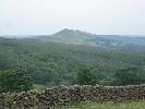 The dominating feature of Hawnby (for me) is Hawnby Hill, looming to the north of the village, and one of the few genuine hills in the moors (Hawnby Hill provides the backdrop to our logo).
Hawnby Parish, entry on the GenUKI genelogy website.
 Hawnby is on Ordnance Survey Explorer Map OL26 (North Yorks Moors Western Area)
Get it from ![]()