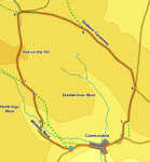
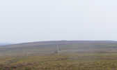
 This is a very fine high level walk on the moors above Commondale, at the upper end of Esk Dale, which stays above 900 feet for well over half of its distance, and is dominated by the open heather moors. It also provides great views into Esk Dale and down the valley towards Whitby and the coast.
This walk does include one section where the path is no longer clearly visible on the ground, but the correct route is marked out by a line of boundary stones. Despite this a compass might be useful.
Ascent: 620ft
Length: 5.5 miles
Map: Explorer 026 North York Moors West
Last Walked: July 2008
Go to printable version
We start at the small parking place on the side of the road just to the west of Commondale.
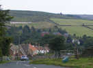 We begin by heading down the hill into the village of Commondale. At the base of the hill continue along the main road as it climbs back out of the village to the east, passing the church and an outdoors activity centre.
 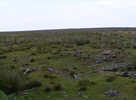 The OS map shows this path running towards a small patch of woodland, but it soon becomes clear that the trees no longer exist. Follow the path until it reaches a small stream running in a small dip, with piles of earth on the far side. Turn right and follow this stream up the hillside until it brings us to a stone wall. This wall used to surround the trees, but now only contains their stumps.
The official footpath passes diagonally through the old forest, but this area gets quite boggy, so instead turn left and follow the wall as it runs along the hillside. Follow it to the northern end of the old forest, then turn right and follow the wall east towards another fence. Our path leads through this gate, before reaching a track. Turn right onto this track and follow it north all the way to a minor road.
 Turn left onto this road and follow it for around 200 feet. Leave the road on the first path that leaves to the left, running along the top of a moorland ridge topped with tumuli. This path is the Quakers's Causeway, which we will follow across the moors for the next mile.
 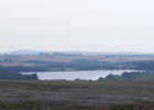 After that mile we reach a junction in the path. Take the left-hand branch, and follow it as it runs across the open moors, before beginning to descend gently towards a stone wall at the edge of some fields on the northern slope of the moors. Follow this path as it curves around to the left, running parallel and to the left of this wall.
 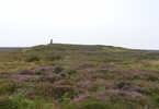 We follow this path to the western end of the stone wall. Just past the wall the path crosses over Tidkinhow Slack, a very minor stream. Here a line of boundary stones run south across the open moors to the left of the path, running south up to the skyline. At this northern end of the line no path is visible, so we have to make our own way across the heather, following the line of boundary stones, until eventually a path does emerge, running almost due south. Follow this path along the line of stones for about half a mile. At this point, just as we approach the skyline, a second path branches off to the right. Follow this path past the tumuli on the hilltop, and then down the far side of the moor towards the valley of Whiteley Beck.
  After just under a fifth of a mile, this track turns right and drops down the hillside towards a farm. At this point a footpath leaves to the left, following the line of some earthworks across the hillside. There are two possible routes back to our starting point from here. We turned right, and followed the track down towards the farm and step nine.
The alternative is to follow the footpath across the hillside. 750 feet after leaving the track, follow the path as it turns to the right and drops down into the valley bottom, then turn left and follow the path as it runs alongside Whiteley Beck, then cross the beck and follow the path back to the footpath.