 This is a full days walk that offers spectacular views across Farndale and Bransdale. The walk along the top half of Rudland Rigg is a fine high level walk, with great views in every direction, while the Rosedale Railway gives superb views of Farndale while crossing some wild rugged country. Finally the final stretch along the River Dove in Farndale provides a marvelous contrast to the wildness of the high ground with a pleasant riverside walk.
Park at the free car park in Low Mills in the heart of Farndale.
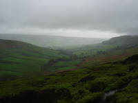
One word of advice for this walk - if the weather begins to close in as you are climbing up out of Farndale, seriously consider doing a different walk. There is little or no shelter to be had on the eight or so miles spent on Rudland Rigg and the Rosedale Railway, and the views disappear. Also, be aware than in daffodil season Farndale came become very busy.
Ascent: 1,400 feet/ 440 m
Length: 14.5 miles/ 23 km
Map: OS Explorer Map OL 26
Last Walked: 20 May 2006
Go to printable version
 We need to exit this field by its top right corner. To reach this point, follow the path that heads south west, climbing the hill to the left. Towards the middle of this field you will find another path crossing this one. Turn right onto this path. You will now be heading north west, climbing the hill to the right. This path continues on along the side of Rudland Rigg, slowly climbing towards the top of the ridge. In wet weather this path quickly resembles a stream, so be prepared.
 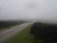 Rudland Rigg separates Farndale and Bransdale. On a good day there will be spectacular views into both dales, as well as of the high ridge of the moors to the north, with Round Hill, the highest point on the moors visible on the sky line (our
 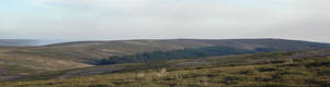 picture shows the view on a less impressive day). Continue along the ridge for three miles until you reach Bloworth Crossing.
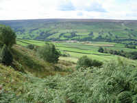
 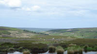 Bloworth Crossing is where the Rosedale Railway crossed over Rudland Rigg on its way to the incline down into the plains north of the moors. Where the track of the railway crosses the track along Rudland Rigg, turn right onto the track bed. We now follow the railway track for five miles as it winds its way around the top of Farndale. This is one of the best paths in the moors, with superb views into Farndale, and a glimpse into Westerdale.
After wet weather the railway appears to be surrounded with wild water, as the drainage channels under the embankments create an unusually large number of rapidly flowing streams.
As we approach the road, ignore the most visible branch of the railway as it heads into a cutting. Instead, keep to the right of this track. You will soon reach a side road heading steeply down the hill into Farndale. On the other side of the road the line of another branch of the railway continues south along the side of Farndale. A clear but narrow path follows the railway, just down the hill from the line of the main road along Blakey Ridge. Follow this path along the line of the railway until it ends.
 A sign on the gate warns of a sudden drop on the other side. Take heed of this warning, and as you pass though the gate keep to the right. Hidden in the undergrowth on the main path there is indeed a short sharp drop where the path has been eroded away. Happily the route around this is fairly clear. The route ahead is nice and clear - a line of open gates following a wall that cuts diagonally across the field pattern, taking us back to the road along the east side of Farndale.