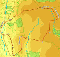
 This walk explores the moors that lie east of Bilsdale and south of the Cleveland Way, a large, dramatic but virtually deserted part of the moors. The walk offers great views over Bilsdale and to the south, as well as visiting the side valley of Tripsdale. We then visit the highest point on the moors, at Round Hill, before returning to Bilsdale.
Ascent: 1,500ft/ 470m
Length: 10 miles/ 17km
Map: Explorer 026 North York Moors West
Last Walked: 8 July 2007
Go to printable version
We start from the public car park at the southern end of Chop Gate, where the main road crosses the River Seph.
 At the end of this field turn right and follow the footpath on the near side of the wall as it heads towards Low Ellermire Farm. In the farm yard the path reaches a track - one branch heads right, down the hill back to the road while the other branch heads left, climbing up slightly before running across the side of the hill. Take this left hand branch. The first part of this track runs between walls, before crossing a field scarred by old industrial workings. Finally, it emerges into a larger field.
Our route across this field leads to a gate on the opposite side of the field, downhill and to the right of our starting position. The best way across this field is to turn right and head down hill until level with the gate and then turn left and cross the field. On the far side of this gate a clear track leads south across the next field, soon joining a farm road that leads to Cam House.
We join this road at the tip of U-bent in the road. According to the OS map we need to turn right onto this road, follow it until it turns to the right to head down towards the main road, and at that point leave the lane to the left, heading south along the edge of the next field. However, on my last visit that route was blocked. Instead, almost immediately after turning right onto the lane, look for a clear footpath that heads south through this first field, running level across the side of the hill. Follow this path three-quarters of the way down this field, and then cross over a stile that takes us into the field to the right. Continue south along the edge of this field.
 After a short scramble we reach a track that runs along the top of Nap Ridge. Turn left and follow this path as it runs north along the ridge line, with Bilsdale to the left and Tripsdale to the right.
 We continue along this track until we reach a second track that leaves to the right, heading down into Tripsdale. Follow this track as it zigzags down in the valley, and then climbs back up out of the other side. On the far side of the valley continue along this track until it splits in two.
  Turn left onto this new track and follow it as it zigzags across the top of the moors. Ignore a side track we pass soon after joining this track, then follow the track as it turns right, left, then right again, dipping down across the top of the valley of Hodge Beck, before finally we reach a cross roads.