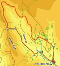
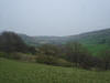
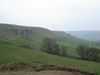
 This walk takes us though the rugged scenery of upper Rosedale, using the old iron railway for most of its route. This is a fantastic walking route, traveling at a high level around the side of the valley, giving impressive views across Rosedale at all times. The route also passes by some very substantial industrial ruins, a reminder of the original purpose of the railway. For the last part of the walk we come off the hills and follow the valley bottom, meeting up with the River Seven, last seen at the very northern tip of the valley.
Ascent: 1,500ft/ 470m
Length: 10.5 miles/ 17km
Map: Explorer 026 North York Moors West
Last Walked: 21 April 2007
Go to printable version
We start from the free car park on the road east out of Rosedale Abbey. This is a popular village, so on a busy summer day this car park may well fill early.
 After just under a mile we reach a public footbridge over the beck. Cross this bridge and follow the path that continues to head north, still generally following the line of Northdale Beck while also gently climbing up the side of the hill. Our path crosses the side road that leads into North Dale, and then begins to climb rather more steeply up the side of the hill. Towards the top of this climb there is now small reservoir, which we pass to the left.
 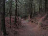 Just after passing this reservoir our path joins a track at a t-junction. Turn left onto this track, and follow it until it curves slightly to the left. Here a footpath leaves to the right, cutting across to a road. Take this footpath. At the road turn right. After a very short distance on the road a footpath turns left and leads into a small plantation. Take this footpath. We are now on the track of the Rosedale Railway. Follow the railway as it runs north west through the trees.
 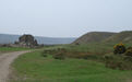 At the t-junction turn right, and follow the track uphill as it passes through a farmyard. Just beyond the farm, the track swings away to the left, while the signposted right of way continues north up the hill. Ignore the right of way and turn left to follow the track (which runs across access land at this point to reach the railway). We are now close to the railway again, as demonstrated by the industrial remains.
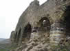
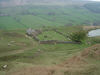
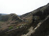
As we cross this wide flat area the route of the railway is not entirely clear, but as we reach the far end all becomes clear - the railway itself runs to the left of the bank that has been visible since we turned left. From here the route onwards becomes clear for just under five miles - follow the route of the railway as it runs up the eastern side of Rosedale, past a series of impressive industrial ruins, curves around the top of the valley and begins to head back south down the valley.
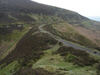
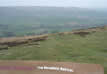 We remain on the track of the railway until we reach the point where the railway crossed over into Farndale. The first warning that we are approaching this point comes when a farm track crosses the railway heading down into Rosedale. Just under a quarter of a mile later, we reach the crossing point, and the car park on Blakey Ridge. Here a right of way is signposted heading straight down the side of the bank (see picture). Turn left and follow this path.
  We follow this path past the first buildings in Thorgill, before crossing a stile that leads into a field to the left (on a signposted footpath). Our route through this field is slightly complicated. The OS map shows a small plantation to our right, with a wall just beyond it, and a foot bridge in the far right corner of the field. That wall no longer exists. On passing the small plantation another small group of trees come into sight, Our bridge is tucked away just behind these trees. On the far side of this bridge we find ourselves on a narrow strip of open land with trees and a stream to the left and Low Thorgill Farm to the right. Head down this strip of land.
  The path emerges into the next field on a slight ridge. Here the stream swings away to the left and then back to the right. Head straight on in the same direction we have just come from, aiming for the trees directly ahead (and slightly downhill). Here there is another bridge over the stream. On the far side of this bridge there are two paths. One continues straight on across the field. Ignore this path and instead turn right and follow the path that follows the line of the stream. This path soon joins a farm track and follows it through the next two fields.
  In the second field the track follows the right hand border of the field, before swinging around to the left. At the tip of this curve a footpath is signposted heading through a gate. Turn right onto this path, and follow it all the way back into Rosedale Abbey. Pick your own way back through the streets of the village to your starting point.