|
|
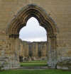 The monks of Byland Abbey wandered around the local moors
before eventually settling here, just south of the southern escarpment that marks the end of the high ground. Work at Byland began in 1177, where they produced a church larger than those at Rievaulx or Fountains Abbey. Sadly, the remains at Byland are less extensive than either either of those locations. The western front still survives, giving a good impression of just how big the abbey church originally was.
The monks of Byland Abbey wandered around the local moors
before eventually settling here, just south of the southern escarpment that marks the end of the high ground. Work at Byland began in 1177, where they produced a church larger than those at Rievaulx or Fountains Abbey. Sadly, the remains at Byland are less extensive than either either of those locations. The western front still survives, giving a good impression of just how big the abbey church originally was.
 Their home at Old Byland was abandoned because it was too close to Rievaulx, and the bells were interfering with each other. Another site at Hood (under Sutton Bank) had been found to be too small for the expanding house.
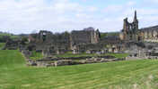 Like Rievaulx, Byland Abbey was a Cistercian monasteries. The Cistercians played a major part in the settlement of the moors, and both houses controlled large areas of land, including most of Bilsdale. The high moors were surrounded by a ring of monasteries, from Byland and Rievaulx to the south up to Guisborough and Whitby on their northern edge.
Car park and public toilets at the Abbey, which in in the care of English Heritage.
Abbey Inn, just opposite the Abbey
 Byland Abbey is on Ordnance Survey Explorer Map OL26 (North Yorks Moors Western Area)
Get it from ![]()