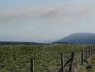
 Jerry Noddle is a wooded head land at the northern edge of Dalby Forest. It lies on the edge of the Tabular hills, with views north over the high moors (when the trees allow).Dalby Forest is Forestry Commission access land, and so Jerry Noddle can be reached on the forest tracks. Our picture shows Jerry Noddle seen from the top of Newgate Brow.
Grid Reference: SE 907 920. Jerry Noddle is about a mile east of the car park at Crosscliff Wood.
 Jerry Noddle is on Ordnance Survey Explorer Map OL27 (North Yorks Moors Eastern Area)
Get it from ![]()