|
|
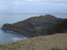
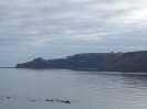 Tiny community on the clifftop opposite Runswick Bay. The views from the cliffs around Kettleness are superb, both northwards towards Runswick Bay, and as you follow the Cleveland Way to the south east, over the coast towards Whitby. In 1829 the clifftop setting claimed its price, when the entire village slid into the sea, although luckily there had been plenty of warning, and the villagers had been evacuated.
 The Ordnance Survey map shows a path down to the beach west of the village. Although this author did not attempt the path, some evidence of its existance was visible.
The headland to the north east of Kettleness (Kettleness Point), has been heavily quarried in the past to produce Alum, an essential requirement of the clothing industry before the discovery of modern dyes.
The railway line came later than the quarries. It was built to connect Middlesbrough to Whitby, and was built in the 1870s, running for eighty years, before closing at the end of the 1950s.
Grid Reference: NZ 830 156
One and a half miles north of the A174, west of Whitby
Limited parking.
 Kettleness is on Ordnance Survey Explorer Map OL27 (North Yorks Moors Eastern Area)
Get it from ![]()