|
|
 Despite appearances, this is a recent addition to the landscape. It was devised by Thomas Taylor, after he had seen the Uffington horse in Berkshire. He managed to convince John Hodgson, the schoolmaster of Kilburn to help. The horse was carved from the hillside in 1857 with the help of 30 of Hodgson's pupils. It is 325 feet long and 227 feet high, and is large enough for its outline to be marked on the 1:25,000 scale Ordnance Survey map!
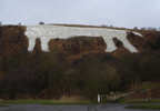 Taylor faced one major problem. The Berkshire horse is carved into chalk hills, but the Hambleton Hills are pale limestone, so the Kilburn horse needs fairly constant maintainance to preserve its appearance. The horse was originally simply painted onto the hill using whitewash, although now chalk chippings are used.
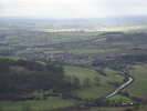
 The White Horse is really designed to be seen from a distance. Approaching the moors along the A1 or the A19 it is clearly visible. From the car park at its base, the view of a headless horse. From above the view of the horse is even worse, but the view out to the south more than makes up for that!
Despite the relatively poor view, the White Horse is worth a visit, partly for the view from the top, but mostly because it is only up-close that you begin to appreciate how much effort must have gone into its creation. The steepness of the slope, which makes the horse visible from such a distance, also made it very hard to actually create, and now presents its own problems as the chalk chipping are constantly being washed away.
Grid Reference: SE 513 812
There is a car park below the horse (SE 514 811) and another just above (SE 517 814). I prefer to approach the White Horse using the clifftop path from Sutton Bank.
 The White Horse of Kilburn is on Ordnance Survey Explorer Map OL26 (North Yorks Moors Western Area)
Get it from ![]()