|
|
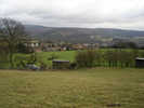
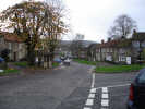 Osmotherley is one of the larger villages in the national park. It is superbly located in a fold in the the hills, where the Hambleton and Cleveland hills meet, and makes a great base for a walking holiday. The village square feels like it belongs in a much bigger place.
 Osmotherley is a viking era name, coming from Asmund's Leah, leah being old English for a clearing. A more recent legend claims that the village was named after a Saxon prince called Osway and his mother were both buried in the area (Os - "by his" - mother - ley).
 The village has several religious associations. It has one of of the oldest Methodist chapels in the country, built in 1754, and used by John Welsey himself on some of his sixteen visits to the village. After a break of over a century, the Methodists returned to the original chapel in 1977.
Just outside the village, on a terrace in the hills, is the Lady Chapel. This medieval chapel was licensed for mass in 1397, before being given to the monks of Mount Grace priory in the following year. After the dissolution of the monasteries under Henry VIII, the Lady Chapel became a site of Catholic pilgrimage for many years, with worshipers recorded in 1643, nearly a century after Henry's death. The chapel was restored between 1942 and 1960 by the Roman Catholic diocese of Middlesbrough, and is now in regular use again.
For a complete change of subject, the public toilets in Osmotherley are worth a visit in their own right. They are kept in perfect condition and are after dotted with thank-you notes!
 The
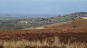
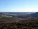
The 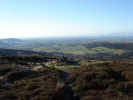 view to the south is dominated by Black Hambleton, which provides some of the best viewpoints on the moors, combining the same views to the west as the more famous viewpoint at Sutton Bank, while also providing impressive views east into the heart of the national park.
Osmotherley has the rare distinction of being on two long distance footpaths. The Cleveland Way drops down into the village after passing Black Hambleton, while the Lyke Wake Walk actually starts in the village. The Coast to Coast walk also passes within a short distance of the village,
 Grid Reference: SE 455 975
Osmotherley can be found just east of the junction between the A684 from Northallerton and the A19. It can also be approached from the east, along a narrow winding road from Hornby that follows the River Rye almost to its source, before crossing the western escarpment of the moors just below Black Hambleton. A scenic drive, but not one to try in the dark or the fog!
The Osmotherley Walking Shop provides a friendly service and a good range of Brasher and Zamberlan boots as well as Craghoppers Clothing.
The Queen Catherine Hotel named after Queen Catherine of Aragon, possibly the only pub in the country still named after Henry VIII's first queen.
The Golden Lion: pub on the village square
Chequers bed and breakfast and tea room, on the old drovers road that runs along the ridge above the village to the east.
Vane House bed and breakfast in the heart of the village
There is a post office and village shop, just north of the market square.
Mount Grace Priory is just over a mile from the village to the north west.
Cod Beck Reservoir is a mile north of the village.
 Osmotherley is on Ordnance Survey Explorer Map OL26 (North Yorks Moors Western Area)
Get it from ![]()