 Like many villages on the southern edge of the moors, Oswaldkirk is spread out along a single road running west to east at the base of a slope. However, here the slope on the northern side of the village is the last remnant of the western escarpment of the moors, and so is much steeper than the gentle gradients found further east. Oswaldkirk is actually at the eastern end of this steep slope, and at the eastern
  end of the village it fades away as the Moors meet the Howardian Hills.
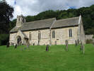
The village has two churches. As one would expect this close to Ampleforth, there is a modern Catholic Church, near the middle of the village. In contrast, the Church of St. Oswald includes some Anglo-Saxon fragments, although the bulk of the church is a little newer!
Grid Reference: SE 622 790
The Malt Shovel, public house, serves food.
 Swainby is on Ordnance Survey Explorer Map OL26 (North Yorks Moors Western Area)
Get it from ![]()