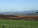
 The Leven rises in the northern tip of the North York Moors, but quickly turns west to flow out of the hills. For most of its course it runs across the flat lands to the north of the Cleveland Hills, where it is familiar to visitors to Stokesley and Great Ayton.
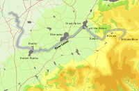
The Leven rises in the same hills as the Esk, and at one point reaches within a third of a mile of Sleddale Beck, one of the tributories of the Esk. The two river systems thus form a single long valley that seperates the northern moors from the heart of the district. The gap formed by the Leven as it flows west is also used by the railway to Whitby.
The Leven rises on Warren Moor, the moor to the south of the village of Kildale
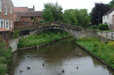 The Leven flows east for a short distance then curves around to the left, running around the north and western flanks of Warren Moor, passing to the north of Kildale village. It then emerges from the moors and flows through Great Ayton, Stokesley and Hutton Rudby before joining the Tees at Yarm.
Lonsdale Beck
Dundale Beck
Otter Hills Beck
Main Stell
Ings Beck
West Beck
River Tame
Alum Beck
Carr Stell
Coul Beck
Fanny Bell's Gill
East Gill