|
|
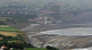
 Robin Hood's Bay is one of the best known villages on the North York Moors, famous for the way the old part of the village clings onto the hillside between the cliff top and the shore. The village is built into the only real gap in the cliffs that line the coast between Scarborough and Whitby.
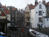
The village is split into two distinct sections - the cliff top village and the more famous Bay Town. Only one street runs down from the cliff top to the sea, and that road is closed to tourist cars, so the visitor has to explore the village on foot. The only other main street in the village, King Street, starts at the water front, but now ends rather suddenly at the sea wall. A  network of small alleyways makes up the rest of the village, lined with a surprising number of small shops.
Access to the beach is via a flight of stairs that climbs up over a ridge just to the right of the old Coastguard Station.
 The village was famous for its smugglers - it was once said that smuggled goods could get from the harbour to the cliff top without ever seeing the light of day, passing through a network of linked cellars and buildings all the way up the hill. Given how closely packed the buildings are, this is entirely believable.
Like many villages on the east coast, Robin Hood's Bay has been greatly threatened by erosion, and a number of buildings lost to the sea - even the original main street had gone, swept away in 1780. At the moment that erosion is being held back by a modern sea wall, which also provides an alternative route between the harbour and the cliff top.
 Robin Hood's Bay has a very distinctive beach, mostly made up of a series of rocky reefs that stretch out to sea. As a result the beach is full of rock pools at low tide, making it an ideal place for the naturalist.
Like many parts of the moors, Robin Hood's Bay has some industrial history. From 1745 it was used as a port for ironstone nodules, which were gathered on the foreshore and shipped to Whitehall furnace on the Wear near Chester-le-Street.
Robin Hood's Bay Museum
A number of second hand book shops
The Old Coastguard Station
Large number of places to eat including pub on the waterfront and a good fish and chip shop
 Robin Hood's Bay is on Ordnance Survey Explorer Map OL27 (North Yorks Moors Eastern Area)
Get it from ![]()