|
|
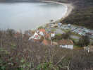 If you don't trust your car on the road down into Runswick Bay, then you can park at Runswick Bank Top, and either admire the views, or walk down into the Bay. The views from Bank Top are impressive in their own right, along the entire length of Runswick Bay and on to the headland beyond, the site of a Roman signal station.
Even the modern road down into Runswick Bay seems alarmingly steep, but if you want to see a truly scarey road then it is still possible to walk down the original road (as described by James Herriot in ...). Just beyond what is now the end of the road, a path seems to dive away down the cliff to the left, before performing a sudden, almost mid air dogleg and heading down into the Bay. A close examination of the start of this path will reveal curb stones and a tarmaced surface - this precipitate path was once the road!
Car Park, Public Toilets
Two Hotels
 Runswick Bank Top is on Ordnance Survey Explorer Map OL27 (North Yorks Moors Eastern Area)
Get it from ![]()