|
|
 Long thin village on a spur of land that narrows into a ridge as it runs thrugh Mulgrave Woods before reaching the coast at Sandsend.
Ugthorpe was an important Catholic centre in the seventeenth century. This was because of the presense of Father Nicholas Postgate, the 'Martyr of the Moors'. He had trained as a catholic priest in France before returning to Yorkshire to act as a chaplain to some of the important Catholic families in the area. Around 1650 he moved to Ugthorpe, from where he turned his attention to the Catholics of the moors. Eventually he fell foul of the reaction to the Popish Plot of 1678 and was betrayed by a local man. After his arrest, he was taken to York, tried and executed, despite being in his eighties by this time.
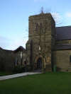 This heritage survives in the form of Ugthorpe's Catholic church, built in 1855.
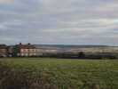
This is a wide open landscape, with sweeping views, especially towards the south and east. It feels very much like the higher moorland and gives something of a feel of what the moors might look like if they had evee been farmed.
Village Pub at west end of village.
Fairly easy off-road parking.
 Ugthorpe is on Ordnance Survey Explorer Map OL27 (North Yorks Moors Eastern Area)
Get it from ![]()