NZ7805/01: The Glaisdale Round
 This is a fine high level walk that will take you all around Glaisdale. Starting on Glaisdale Rigg, the views soon open up into Great Fryup Dale. Around the head of Glaisdale the walk skirts the edge of the highest moors - at 1,300 feet Glaisdale Moor is one of the highest. From here wide views open up - I could see the radar base at Fylingdales, nine miles away across open moors. Finally, as you return along the edge of Egton High Moor, the views open out down the lower Esk valley.
You can of course drive to the start of this walk, but here there is the option to begin from the railway station at Carr End. If driving, you will find some space to part at Carr End, but might be forced to move up to Glaisdale itself, where there is more room - the only problem is that your walk will finish with a climb.
Ascent: 1100 feet/ 335 meters
Length: 11.0 miles/ 17.5 km
Map: OS Explorer Map OL 27
Last Walked: 2nd July 2006
Go to printable version
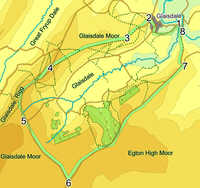
- 1 (NZ 782 054)
- Follow the road from Carr End towards Glaisdale, clearly visible clinging to the hillside in front of you (ignore the lane marked local traffic only). The road is fairly level for most of its route, passing the pub at Carr End, and a tennis court just outside Glaisdale, before begining to climb into Glaisdale village.
- 2 (NZ 773 057)
- Follow the main road through Glaisdale as it climbs steadily through the village. At the top of the climb you will find the village green. Turn left here onto a lane that continues to climb past more houses before emerging onto Glaisdale Rigg. At the end of the lane follow the track that continues up the Rigg in the same direction.
- 3 (NZ 765 049)
 After about a third of a mile of track, you will pass a small pond on the left of the path. Just beyond this, the main track swings slightly to the right and continues up the Rigg. Follow this track, ignoring a side track that continues straight ahead before dropping back into Glaisdale. This track now continues straight along the Rigg, with great views into Glaisdale and increasing hints of a view into Great Fryup Dale.
- 4 (NZ 740 040)
- Our track now joins a road that we will be following for much of the rest of the walk. For most of the walk there is a suitable grassy verge, and when this author was there, very little traffic. Follow this road as it curves gently to the left. From here you will get the best views into Great Fryup Dale.
- 5 (NZ 731 022)
- The road has now curved around to head almost south-east, along the edge of Glaisdale Moor. We are now walking around the head of Glaisdale, with great views down the length of the valley. Ignore the road that plummets down into the valley, and stick to high road.
- 6 (NZ 745 000)
- Follow our quiet road down to a T-Junction with another road. Turn left onto this road. We are now on the final leg of our Glaisdale Round. Along this stretch the views stretch out from the lower Esk Valley, across the views around Goathland and down to Fylingdale and Whinny Nab.
- 7 (NZ 784 041)
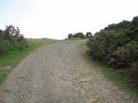
- After three miles on this road, we pass some earthworks, then pass over a cattle grid. Soon after this the road begins to decend steeply towards Egton Bridge. Before we decend too far, turn left into a smaller lane. Follow this lane as it turns to the right, and begins to decend back towards Carr End. The lane soon becomes a rough track as it passes through Arnecliffe Wood. The track is not as dramatically positioned as it first looks on the map, where it appears to follow the spur of the ridge down. In fact, it is a little to the left of the ridge.
- 8 (NZ 783 054)
- At the base of the ridge, turn left. Cross the footbridge across the the stream here, and climb back up onto the road, where you have emerged next to the pub. If you have parked in Glaisdale see step one for returning to the car.
Map
 This walk is on Ordnance Survey Explorer Map OL27 (North Yorks Moors Eastern Area)
Get it from 