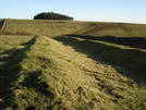
 Far Black Rigg is typical of the isolated headlands on the tabular hills. In this case, the rigg lies between the major valley coming out of the Hole of Horcum, and the smaller, but still steep sided valley of Black Griff. What makes Far Black Rigg interesting is the Cross Dyke that cuts across the head of the rigg. This is a great example of the many pre-historical earthworks that are scattered around the moors. In this case, the purpose of the dyke was probably to protect a settlement on the rigg. With steep slopes on three sides, the dyke would complete the protection of the hilltop community.
The path across the rigg also give great views west over Levisham Moor.
Grid Reference: SE 842 920
 Far Black Rigg is on Ordnance Survey Explorer Map OL27 (North Yorks Moors Eastern Area)
Get it from ![]()