|
|
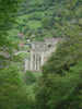
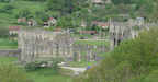 Rievaulx Abbey was one of the most important Cistercian abbeys in England, and its ruins are now amongst the best preserved, sitting in an area of park-like grass in the narrow valley of the River Rye.
Rievaulx Abbey itself was not actually built in a deserted area. The village of Griff was only one mile south east of the abbey site (so close in fact that it was emptied to give the Monks more solitude). Helmsley was only just over two miles to the east, Scawton just under two miles to the west and Hawnby three and half miles further up Ryedale. Only to the north east, in the direct of what became Rievaulx Moor, was the area completely deserted.
 The nearby moors were the key to the location of Rievaulx. The first Cistercian abbey in England, Waverley (Surrey) had been founded in 1128. At the time the head of the Cistercian order was Bernard of Clairvaux, a close friend of Archbishop Thurstan of York. It was inevitable that the Cistercians would expand into the north of England. All they needed was the land, and that came from Walter Espec, lord of Helmsley, who owned vast expanses of low value moorland.
The monks of Rievaulx turned this expanse of unused moorland into a massive sheep farm. The Cistercian order was unusual in that as well as containing traditional monks it also included a much larger group of lay brothers, who lived alongside the monks but worked on the Abbey's estates. This helped to give the Cistercians the manpower to exploit the lands they were given. In the case of Rievaulx the end result was that by the end of the thirteenth century the abbey owned a herd of 12,000 sheep, and transformed large areas of the moors.
 Rievaulx Abbey was an early centre of the iron industry. By 1540 the abbey owned iron forges at Laskill on Bilsdale, and at the abbey site itself. These early forges needed two hearths - a bloom hearth to turn the iron ore in iron blooms (spongy lumps of iron) and a string hearth in which impurities were beaten out of the red hot blooms. The monks kept improving their forges. In 1540 a second bloom hearth was added, and a water-wheel powered trip hammer was built for the string hearth. This version of the forge could produce 16 cwts of iron per week (there were 20 cwts to an imperial tonne), or just over 40 tons in a year. These forges needed a reliable supply of charcoal, and so twenty areas of coppiced woodland were created over the next twenty years. The forge was rebuilt again in 1576, this time as the first blast furnace in Yorkshire. When first built this could produce 100 tons of pig iron per year and by 1624 that had increased again, to 280 tons. The blast furnace remained in use until 1647.
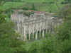 The abbey church is now ruined, but larger parts do survive - the chancel and transept walls remain at their full height, while the east end of the Abbey church, which was rebuilt in 1225, remains a masterpiece of English Gothic.
The most famous inhabitant of the abbey was St. Ailred, the third abbot. He joined the abbey community in 1134, only three years after Rievaulx had been founded, and nearly sixty years before the first church was complete. He remained at Rievaulx until his death, only leaving for four years (1143-47) to serve as abbot of Revesby. He returned to Rievaulx in 1147 to become its most successful abbot. By the time he died the abbey community contained 150 choir monks and 500 lay brothers and servants, and had founded five daughter houses across England and Scotland.
 Rievaulx as at its most prosperous during Ailred's time. It remained prosperous until 1322, when the abbey was sacked by the Scots, and this triggered a decline that saw the annual income of the abbey eventually fall to £278 at the time of the dissolution.
The best views of the abbey ruins are from Rievaulx Terrace. This grassy walkway on the hill to the east of the abbey was built by Thomas Duncombe III of Duncombe Park in 1758, and was built as a promenade and viewpoint over the romantic ruins of the abbey. The terrace is now in the hands of the National Trust.
 Rievaulx is on Ordnance Survey Explorer Map OL26 (North Yorks Moors Western Area)
Get it from ![]()