 Rye Dale is the main valley in the south-western corner of the North York Moors, running from the high moors east of Osmotherley, through some very remove country and past the historic remains of Rievaulx Abbey, before leaving the Moors at Helmsley.
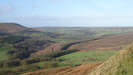
 Rye Dale runs from north-west to south-east across the south-western part of the North York Moors. The Rye rises in wide expanses of gentle moorland in the Cleveland Hills, and then runs south-east through an attractive, often wood lined valley, bordered to the west by the high ground of Arden Great Moor and a series of minor side valleys, while on the east a series of ridges climb up to Bilsdale West Moor. Much of this part of the dale can be followed on the minor road from Osmotherley to Hawnby and Helmsley. The first village on the river is Hawnby, which sits at the southern end of Hawnby Hill, one of the few isolated summits in the area. Most of Hawnby is above the river, but the church and some outlying buildings are right on the river.
Just below Hawnby the River Seph joined the Rye, flowing out of Bilsdale. Somewhat confusingly (including for me) the main road follows Bilsdale, which is also a rather more impressive and coherent valley than upper Rye Dale, straighter and with steeper sides than Rye Dale.
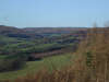
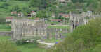 Below the junction with the Seph, Rye Dale becomes narrower and steeper sided, with the river flowing below wooded slopes. This brings us past two impressive historical monuments - the impressive ruins of Rievaulx Abbey, in the river valley itself, and Duncombe Park, which sits on the higher ground above the river valley, but with a park that spreads down to the river. Just above the abbey ruins is Rievaulx Terrace, an impressive short walk between Io nic and Tuscan Temples, originally built by the Duncombes of Duncombe Park.
 Just part Duncombe Park the river curves around to the north, then turns east to flow past the southern edge of Helmsley, the largest town in Rye Dale within the National Park. The historical buildings continue at Helmsley, with its ruined castle, and outside the park, with the NT property of Nunnington Hall just a few miles to the south-east.
The valley has also given its name to one of the administrative divisions of Yorkshire, Ryedale, which covers the south-western and south-central part of the Moors, most of the Howardian Hills and a large part of the Yorkshire Wolds. Outside the National Park the River Rye runs east across the more level ground between Helmsley and Norton/ Malton, absorbing the Rivers Riccal, Dove and Seven on its way. It runs into the Derwent just to the north of Norton/ Malton. As a result a number of 'Ryedale' villages are not actually in Rye Dale.
Grid Reference: SE 499 971 to SE 612 835
SE5194/01: Arnsgill Valley and Cow Ridge - starts in Rye Dale
SE5489/01: Hawnby Hill - heads north from the village
SE5489/02: Thorodale and Great Arden Moor - starts in Hawnby, crosses the Rye and runs west into one of the longer side valleys.
SE5489/03: Easterside Hill - visits Rye Dale at Hawnby