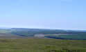
 The Derwent begins life as the only river of the eastern moors, running south east across the moors towards the coast.
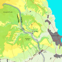
The river changes in character more than most moorland rivers. The upper reaches flow between the northern end of Langdale Forest and the open moors. After four miles the river turns south and runs through Lang Dale, with the narrow ridge of Langdale Rigg to the west and the steep slopes of Broxa Forest to the east.
 After emerging from Lang Dale the Derwent meanders its way through an area of more open farmland, bounded by steep sided but more distance hills. Originally this was the last stretch of the river, and it ran into the sea just to the north of Scarborough.
This all changed during the last ice age. Towards the end of the ice age the glaciers retreated at different speeds, with the thinner glaciers over the Moors melting more quickly than those over the modern North Sea. As a result the Derwent was unable to flow into the sea and a large lake built up to the north of the Tabular Hills. Eventually this lake overflowed the hills penning it in. The resulting flood carved out the Forge Valley.
 The Derwent still flows down the Forge Valley, emerging form the moors between West and East Ayton. At this point the river is only four miles from the coast, but it turns its back to the sea and flows west across the Vale of Pickering. At one point the river ran into a massive lake that covered the vale, but the area has long been drained and the river is canalised for most of this section. Towards the end of this stretch the River Rye flows into the Derwent, bringing with it the waters of every other river in the southern moors.
After flowing through Norton-on-Derwent and Malton the Derwent leaves the flat lands and flows through the north-western part of the Yorkshire Wolds, before eventually flowing into the Ouse just to the east of Selby.
The Ouse then flows east before merging with the Trent to form the Humber, and so the majority of rain that falls on the Moors eventually reached the sea just to the east of Kingston-upon-Hull.
The Derwent rises at Derwent Head, on the high moors just to the east of the radar base at RAF Fylingdales.
Woof Howe Grain
Barley Carr Dike
Harwood Dale Beck
Black Beck
Sow Beck
Lowdales Beck/ Crossdales Beck
River Hertford
Head Dike
Howling Dike
Brompton Beck
Welldale Beck
Ellis Beck
Cripple Beck
Difford Beck
Friar Dike
Scampston Beck
River Rye
Settrington Beck
Menethorpe Beck
Braisthwaites Beck
Evers Beck
Howl Beck
Barlam Beck
Flawwith Beck
Millsike Beck
Throwmires Beck