Rosedale is one of the largest and most impressive valleys in the North York Moors, and the only one of the central dales (Rosedale, Farndale, Bransdale and Bilsdale) to contain a sizable village, Rosedale Abbey. Rosedale is perhaps best known for its industrial ruins, particularly those of East Mines, while for me the best thing about the valley is the abandoned Rosedale Railway, which can be followed on foot around most of the valley. The most impressive stretch runs around the upper reaches of the valley, following a route half way between the valley floor and the open moorland above, and taking us all the way around the wild head of the valley (the same line can be traced around the head of Farndale, providing another great walk).
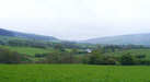 Rosedale is a gentle oasis surrounded by the high moors. This sense of isolation is only increased by the nature of the roads into the valley. A minor road heads across Spaunton Moor from Hutton-le-Hole, dropping steeply down from Bank Top to reach Rosedale Abbey. The main road from the south leaves the A170 at Wrelton, crosses the tabular hills to reach Cropton and then plunges down Cropton Banks before running through the western flank of the great forests that cover the eastern moors. It then passes the mouth of Hartoft, before running up the narrow mouth of Rosedale itself. From the north one has to drive up Castleton Rigg, cross Danby High Moor and drop down Knott Road, or take the very minor roads that meet on the vast moors above Hartoft, before crossing Northdale Rigg and dropping down Heygate Bank.
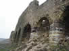
 The 'abbey' of Rosedale Abbey was actually a Cistercian priory, founded in 1158 by William of Rosedale. At its peak it probably only contained nine nuns and a prioress, and only scanty remains can now be seen, close to the current church. Many more dressed stones from the priory can be seen in the village buildings, used during the massive expansion that accompanied the mining boom of the nineteenth century.
For many centuries Rosedale was shaped by the ironstone mines. In the thirteenth century Byland Abbey was granted rights to the iron ore in Rosedale, and produced iron in the valley until the sixteenth century.
 Interest in the Rosedale ironstone was revived during the nineteenth century. By 1850 samples had been taken away to be smelted, and it was discovered to be high quality magnetic iron ore, with a 45% iron yield (compared to 30% at the better end of the Skinningrove ore field). Mines were soon opened, but the biggest problem was how to transport the heavy iron to the iron foundries of Teesside. The solution was a railway that ran around the head of Farndale from Greenhow Moor to Blakey Junction, just to the south of the Lion Inn on Blakey Rigg. This line was built by 1861, and was connected to the main railway network by the steep Ingleby Incline. Laden iron ore wagons were send down the incline, while the engines remained at the upper level, rarely leaving the moors.
A network of smaller tramways then connected Blakey Junction to the mines. East Mines, which now boast the most substantial remains, was connected by 1865. Another line ran south to mines at the southern end of Rosedale, sitting on the western slopes of the valley, at the foot of another incline. This ran down from Bank Top, close to the site of the old Rosedale Chimney, demolished in 1972 for safety reasons.
This railway didn't just serve the Rosedale mines, but was also used by Blakey Mines, on the eastern side of Farndale. Part of the railway south from the junction towards these mines can still be traced on the ground, before ending very suddenly, while another incline once connected the mine itself to the railway.
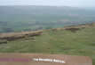 Rosedale is flanked on the west by Blakey Ridge, one of the most impressive of the moorland ridges that separate the valleys. Young Ralph Cross, the basis of the National Park's logo, is located at the head of the ridge, near a small parking area close to a road junction where one of the roads out of Rosedale joins the road along the ridge. The top of the ridge is a stunning viewpoint, with views down Rosedale and north towards Esk Dale and the sea.
| SE7295/01 | Rosedale and Hartoft | 10 miles | Circular | Paths |
| SE7296/01 | Rosedale on the railway | 10.5 miles | Circular | Paths |