Farndale is one of my favourite valleys of the North York Moors, a quieter version of its near neighbour Rosedale, a long steep-sided trench cut into the high moors, with a super mix of a gentle valley bottom, steep sides and wild moorland.
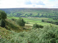 The valley is almost 'cactus' shaped, with a long central valley following the River Dove, and two side branches to make the arms - West Gill near Low Mill and Blakey Gill near Church Houses. Horn Ridge, between the main valley and West Gill, makes a good viewpoint, with easy access from above and below, and there is also a nice path up the valley, In contrast the valley of Blakey Gill is rather inaccessible, lacking a footpath.
Farndale is one of a series of three similar valleys (Bransdale, Farndale and Rosedale) that cut into the high moorlands in the west-centre of the Moors. All three are unusual in that they are enclosed by high ground, with no open end. Instead access to the dales from the south is via narrow steep sided valleys, first cutting into the Tabular Hills and then into southern slopes of the high central moorland. In each case the roads from the south cross the higher ground alongside these valleys. In the case of Farndale the bigger of the two roads
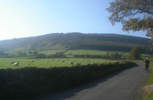 Farndale is somewhat unusual in that it doesn’t contain a village. The largest cluster of buildings is at Low Mill, towards the southern end of the dale. Here there is a small car park, and the start of the wild daffodil walk, but otherwise this is just a small hamlet. Church Houses, towards the middle of the dale, is even smaller. The population of the dale is scattered across its entire length, with farms and houses dotted along the roads that run up the west and east sides of the valley. There are attractive villages just outside the dale - Gillamoor overlooks the entrance to the valley from the south-west, with an impressive 'surprise view' from the edge of the village, while Hutton-le-Hole, to the south-east, is one of the most attractive villages in the entire National Park.
There are some excellent walks on the high ground around Farndale. To the north the old Rosedale Railway runs around the head of the valley, offering great views down the dale. To the west a long track runs along the top of Rudland Rigg, offering a long, high if rather straight route. The two join up at Bloworth Crossing, from where the railway can be followed to the Greenhow Incline.
The eastern ridge, Blakey Ridge, is rather different, lacking a ridge-top path but instead carrying the road north to Castleton in Esk Dale. Towards the northern end is the Lion Inn, an isolated inn in a great location on top of the ridge.
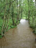 Frustratingly it is rather difficult to walk along the River Dove, which runs the full length of the dale. For most of the valley there is no right of way alongside the river. The only easily accessible part of the river is the mile north of Low Mill, where the daffodil route runs.
Farndale is most famous for those daffodils, an impressive array of wild flowers that spread out along the River Dove. In late April a one-way system is put in place to keep the traffic under control. In early times the daffodils were threatened by the large number of visitors and even by semi-commercial extraction, but they are now properly protected.
Walks
SE 6795/03 Rudland Rigg
SE 6795/02: Farndale North
SE 6899/01: The Farndale Railway
SE 6795/01: Farndale East and Rosedale West