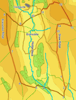
SE 6395/01 Bransdale
 This walk takes us into one of the quietest of the main dales, Bransdale. This enclosed valley is only accessible via two small moorland roads, contains no village and is very rarely visited. This walk begins at the southern approach to the dale, crosses the mouth of the valley, visits both of the flanking moors and crosses the pastoral heart of the dale. Sadly our photographs from this walk have gone missing.
Ascent: 1575ft/ 480m
Length: 9.5 miles/ 15.5km
Map: Explorer 026 North York Moors West
Go to printable version
There are a number of places to park on the side of the road from Fadmoor to Bransdale. This road leads north out of Fadmoor, drops down the front of the Tabular Hills, climbs back up onto the open moors, and then zigzags sharply left then right. Park at the next available place.
1 (SE 635 952)
From our roadside parking place, we start by heading south (down hill), following the road back out of Bransdale.
2 (SE 637 944)
Where the road doubles back to the left, leave it and continue south along a track.
3 (SE 636 939)
This track cuts across the middle of two fields, the first much larger than the second. At the southern corner of the second smaller field, turn sharply right onto a footbath that heads north west along the edge of the field back towards Bransdale. Follow this path all the way down to Hodge Beck.
4 (SE 626 944)
Cross over the beck on a footbridge. On the far side of the beck, the path heads right, up the side of a steep bank. At the edge of the woods, turn left and head straight up the side of the bank, following the field edge towards the ruins of Stork House.
5 (SE 622 944)
At Stork House our path joins a track climbing up out of the valley bottom onto the open moors. Turn left onto this track. A right of way leaves the track just past Stork House - if there is a visible path, then turn right onto it, and follow it as it heads north west towards Lambfold Hill. If not, continue along this track - it reaches the same point, but by a more roundabout route - at every junction in the track, keep to the right, remembering that our target is the top of the ridge. In either case, keep climbing and avoid any paths that lose height.
6 (SE 615 946)
Both routes end up on Lambfold Hill, the southern spur of Bransdale Ridge. Once on the ridge, follow the track that heads north along the top. After a short distance the track reaches one of the roads into Bransdale - follow the road north along the top of the ridge.
7 (SE 609 962)
Leave the road where it turns right to drop down into Bransdale, and follow a track that heads north along Bransdale Ridge.
8 (SE 607 981)
When this track begins curve to the left, look for a public footpath that turns sharply right, and heads south east down the hillside into Bransdale. Follow this path all the way to the road.
9 (SE 615 975)
Cross over the first road on a footpath that heads east towards Colt House Farm and a second road. Also cross the second road, onto a path that heads slightly to the left, towards the stream at the middle of the valley.
10 (SE 621 979)
This path reaches the beck at Bransdale Mill. Pass through the area of buildings, ignore paths leaving left and right along the side of the beck. Instead, look for a path that climbs up the opposite side of the beck, and follow this path as it climbs up to the road on the east side of the valley.
11 (SE 625 981)
At this road, turn left. Stay on the road for around 500 feet, then turn right onto a footpath that climbs steeply up onto the top of the ridge east of Bransdale. This path climbs directly up to a small forest, then cuts across the hillside to the left. At the top of the climb, follow this track as it curves around to the right, eventually heading east towards the ridge line.
12 (SE 634 985)
We follow this track across the top of the moor, until it crosses another track heading north-south along the line of the ridge. Turn right onto this track.
13 (SE 640 974)
We follow this track south for about an eighth of a mile, then turn right onto another track heading west across the moors (it may be possible to cut a corner here using a footpath, but in poor visibility, or if the path is no longer clear, stick to the tracks).
14 (SE 634 975)
We follow this new track as it dips down across the valley of Ouse Gill and then up onto Shar Ridge. Turn left onto the track that follows the top of Shaw Ridge, heading south back towards our starting point.
15 (SE 633 972)
Ignore any paths that leave this track to either side, and follow it all the way back to the road we started from.