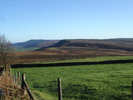
![]() This short walk from Osmotherley will reward you with spectacular view in every direction. On a clear day the Pennine hills are visible to the west. From the top of Beacon Hill you can see the dramatic northern escapement of the moors, stretching away to Roseberry Topping. To the east the view is of the high moors, running east towards Bilsdale. Finally, to the south Black Hambleton dominates the skyline.
This short walk from Osmotherley will reward you with spectacular view in every direction. On a clear day the Pennine hills are visible to the west. From the top of Beacon Hill you can see the dramatic northern escapement of the moors, stretching away to Roseberry Topping. To the east the view is of the high moors, running east towards Bilsdale. Finally, to the south Black Hambleton dominates the skyline.
There is plenty of roadside parking in Osmotherley.
Ascent: 500 feet/ 150 m
Length: 3.5 miles/ 6 km
Map: OS Explorer Map OL 26
Last Walked: 9 December 2006
Go to printable version
 Here the lane splits in two. Our route continues on level around the curve of the hill.
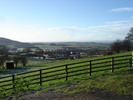
Just beyond the junction there is a good viewpoint looking south to Osmotherley and along the western edge of the moors.
Here the lane splits in two. Our route continues on level around the curve of the hill.
Just beyond the junction there is a good viewpoint looking south to Osmotherley and along the western edge of the moors.
The right hand turn heads up the side of the hill to the Lady's Chapel, a fourteenth century chapel that has now been restored and is still in regular use. If you wish to visit the chapel, it is a quarter of a mile along the right hand turn. You will need to return the way you came after your visit to the chapel.
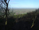
 At the edge of the woods the path splits in two. We take the right hand branch, heading uphill into the trees. After about a third of a mile we reach the top of the bank. From here we follow the path north along the top of the bank. This is the section of the walk with the best views. As we move north, the views become more and more extensive, until near the top of Beacon Hill the view stretches from Wensleydale in the distant west to Guisborough, thirteen miles to the north east.
![]()
 Soon after passing the trig point at the top of Beacon Hill, the path begins to descend towards Scarth Nick. Where the fields give way
 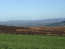 to open moorland, we turn sharply right, onto a lane that heads back south between the fields. After about a quarter of a mile the lane joins a tarmaced road, and continue to head south, descending gently towards Osmotherley.