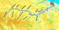

 The River Esk is the longest river within the North York Moors, the only one to from from west to east and the only one to flow into the sea (at Whitby). The two sides of the valley are different in character - to the north the valley is lined by an almost unbroken line of lower moors but to the south a series of side-valleys (Danby Dale,
  Little Fryup Dale, Great Fryup Dale and Glaisdale), run back into the highest ground in the National Park. A whole series of villages line the Esk, but the most interesting settlement on the river is Whitby, at the mouth of the river.
 The river is crossed by a number of famous bridges. Duck Bridge near Danby is an impressive 14th arched packhorse bridge, possibly named after a George Duck who may have paid for its repair, although it may have originally been named Duke's Bridge.
Glaisdale has Begger's Bridge, built by Tom Ferris, a local man who left to make his fortune, eventually becoming Lord Mayor of Hull.
Lealholm offers a simpler way across the river - a popular set of stepping stones.
The River Esk rises at the top of Westerdale, and is formed by the merger of a large number of small streams known rather charmingly as Esklets.
The Esk runs north-est through Westerdale and then flows east down Esk Dale, reaching the sea at Whitby.
Yaud Sikes Gill
White Gill
Clough Gill
Stockdale Beck
Hole Gate
Old Mill Stream
Stocking Dike
Bagdale
Whyett Beck
Hob Hole Beck
Commondale Beck
Danby Beck
Ewe Crag Beck
Clither Beck
Foul Sike
Little Fryup Beck
Great Fryup Beck
Eller Beck
Wood Beck
Broad Carr Beck
Stonegate Beck
Church Dale Beck
Glaisdale Beck
Butter Beck
Blue Beck
Murk Esk
Car Scar Beck
Murk Beck Slack
Lady Hilda's Beck
Iburndale Beck
Buskey Beck
Shawn Riggs Beck
Cock Mill Beck
Spital Beck