 Baysdale lies at the western end of Esk Dale, merging with Westerdale just upstream of Dibble Bridge, west of Castleton.
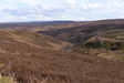
The valley feels very remote, at least in part because of the limited road access but it is actually very close to the edge of the Moors. The minor road that climbs out of the valley from Baysdale Abbey reaches the top of the western escarpment very quickly, and brings you out on the road to Kildale.
The valley begins just to the east of Burton Howe, at 424m/ 1,419 ft one of the highest spots in the moors. The narrow wooded valley of Grain Beck runs north from there, between Baysdale Moor to the east and Ingleby Moor to the west. At Baysdale Abbey it merges with the valley of Black Beck, and curves around to the east, remaining steep sided all the way to the Esk.
 Geologically the upper sides of the valley are made up of sandstone, while the lower slopes and valley floor cut into the upper Lias rocks, shale and ironstone at this stage.
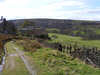
The valley bottom is only reached by two roads - the dead-end to Baysdale Abbey and a minor road that leaves the Kildale to Esk Dale road just to the east of Kildale and runs into Westerdale village. On its way it drops down to Hob Hole in Baysdale, where there is a limited amount of parking, and some lovely streamside walking.
 Upper Baysdale is one of the few areas in the park where Juniper can be found.
Baysdale Abbey was actually a Cistercian nunnery founded in the twelfth century. A medieval ribbed bridge survives and there is now a farm on the site.
Baysdale no longer contains any villages, but there was probably a medieval settlement on the eastern tip of Westerdale Moor, at the lower reaches of the valley.
The Cleveland Way runs along the high ground on the western edge of Baysdale, but doesn’t drop down into the valley.
We have a walk that visits Baysdale from Hob Hole
Grid Reference: NY 619 038 to NZ 671 077