|
|
 When approached by road from the south, Gillamoor looks like a normal rural village. You drive through gentle countryside with the most spectacular views away to the south across the Yorkshire Wolds. However, this is an illusion. Gillamoor and its near neighbour Fadmoor are built on the flat top of one of the tabular hills. As you drive north across the middle of the hill, steep sides valleys are just out of sight on each side (Kirkdale and Sleightholmedale to the west and the southern entrance to Farndale to the east).
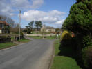
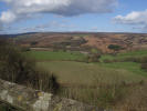 The village itself is an attractive stone-built village, typical of the area. It is only when you reach the eastern end of the village that you realise that you have actually driven right to the edge of the high moors. Just to the left of the village church is Gillamoor's 'Surprise View'. The Church has been built right on the edge of a moorland escarpment, dropping sharply for 150 feet to the River Dove and the southern entrance to Farndale.
 Grid Reference: SE 683 900, two and a half miles north of Kirkbymoorside. The main road through Kirkbymoorside turns into the Gillamoor road as it leaves the town.
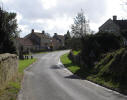 Gillamoor is probably best approached as the destination of a walk, partly because of the surprise view and partly because just about every walk from Gillamoor would end with a sharp climb back onto the Tabular hills.
Gillamoor is visited on Walk SE8685/01: Kirkdale and Gillamoor
The Royal Oak Inn, serves Black Sheep Fine Ales and offers accomodation.
 Gillamoor is on Ordnance Survey Explorer Map OL26 (North Yorks Moors Western Area)
Get it from ![]()